Steer Home

Main navigation (UK)

  • Sectors
    • Transport
      • Active travel
      • Aviation
      • Freight & logistics
      • Ports & maritime
      • Rail, bus & transit
      • Roads, bridges & tunnels
      • Urban & rural mobility
    • Places & communities
      • Commercial real estate & housing
      • Community planning
      • Economic development & regeneration
      • Education & health
      • Leisure, arts & culture
      • Sports & major events
    • Resources
      • Energy
      • Property & land
      • Telecommunications & data
      • Water
  • Services
    • Advisory & financial
      • Market research & intelligence
      • Demand & revenue forecasting
      • Business & financial modelling
      • Capital programme advice & assurance
      • Project financing
      • Commercial & technical due diligence
      • Economic impact
    • Strategy & policy
      • Policy development
      • Business case & advocacy
      • New technologies
      • Regulation & competition
      • Sustainability & climate resilience
      • Strategy & management consulting
    • Planning, delivery & experience
      • Community engagement
      • Network design & operation
      • Cost modelling & strategies
      • Feasibility design & detailed design
      • Information & wayfinding
      • Infrastructure & development planning
    • Underpinning capabilities
      • Data science & analytics
      • ESG
      • Equity & inclusion
      • Monitoring & evaluation
  • Projects
  • Insights
Regions
  • Global
  • North America
  • Latin America
  • Europe
  • UK & Ireland
  • India
Search
Contact
  1. Home
  2. Projects
  3. Improving local transit network diagrams
Toronto Transit Commission, Canada

Improving local transit network diagrams

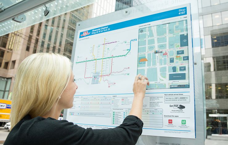
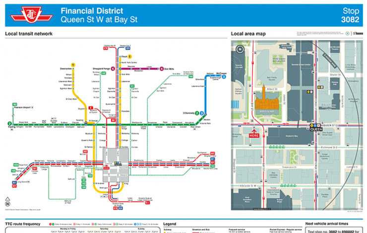
Steer was commissioned with our mapping partners, T-Kartor, by the Toronto Transit Commission (TTC) to improve and systematise the design of their local transit network diagrams and posters. Key to this assignment was the opportunity to integrate the TO360 wayfinding map base to provide consistent information across different transportation environments and modes.

Our approach included analysis and development of a pilot spider map originally developed by TTC to establish and agree a new design standard for stop/hub specific transit information. This included synchronising the map standard with the TO360 graphic design and mapping conventions. The process included intensive transit data analysis (GTFS), stakeholder engagement across TTC departments, and requirements mapping as part of the production process, print testing and documentation of all specifications.

The output of the project consisted of the efficient and quality assured production of over 30 individual posters with customised information per stop. The posters were installed in and around the Financial District, delivering an integrated pedestrian/transit information pilot in the summer of 2015.

On
Steer group

We are Steer

Yes, you are in the right place. After 40 years, we have changed our name from Steer Davies Gleave to mark our growing international footprint and our expanding portfolio into sectors beyond transport.

Explore our new website to learn more about Steer: who we are, how we work and what our future holds.

Complex challenges.
Powerful solutions. 

Footer (UK)

  • Sectors
  • People
  • Services
  • About
  • Projects
  • Careers
  • Insights
  • Contact
  • Events
  • Our impact

©2025 Steer      Legal & policies        Cookie settings

Subscribe to our newsletter

  • Facebook
  • Twitter
  • Linkedin
  • Instagram
  • Spotify

Back to top